


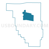
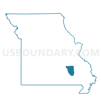
Centerville Voting District, Reynolds County, Missouri
About
Outline

Summary
| Unique Area Identifier | 609546 |
| Name | Centerville Voting District |
| County | Reynolds County |
| State | Missouri |
| Area (square miles) | 56.86 |
| Land Area (square miles) | 56.64 |
| Water Area (square miles) | 0.23 |
| % of Land Area | 99.60 |
| % of Water Area | 0.40 |
| Latitude of the Internal Point | 37.42575270 |
| Longtitude of the Internal Point | -90.98840400 |
Maps

Graphs
Select a template below for downloading or customizing gragh for Centerville Voting District, Reynolds County, Missouri


Neighbors
Neighoring Voting District (by Name) Neighboring Voting District on the Map
- Black Voting District, Reynolds County, MO
- Bunker Voting District, Reynolds County, MO
- Corridon/Reynolds Voting District, Reynolds County, MO
- Ellington No. 2 Voting District, Reynolds County, MO
- Lesterville Voting District, Reynolds County, MO
- Oates Voting District, Reynolds County, MO
- Redford Voting District, Reynolds County, MO
Top 10 Neighboring County Subdivision (by Population) Neighboring County Subdivision on the Map
- Logan township, Reynolds County, MO (2,708)
- Carroll township, Reynolds County, MO (1,314)
- Lesterville township, Reynolds County, MO (744)
- Black River township, Reynolds County, MO (594)
- Jackson township, Reynolds County, MO (504)